- 1. Vångakullen and archaeology
- 2. Vångakullen and archaeology. The methods
- 3. Vångakullen and archaeology. Interpreting the remains
- 4. Vångakullen and archaeology. Complexity of the excavation
- 5. Vångakullen and archaeology. Reconstructing the puzzle
- 6. Vångakullen and archaeology. The importance of analysing the finds
In 2004, Karlskrona Municipality started a water treatment project at Johannishusåsen in Ronneby Municipality. In connection with this, Blekinge Museum was given the opportunity to carry out archaeological excavations along the route of the pipeline. A previously unknown and unexpectedly rich Iron Age settlement was discovered in the village of Västra Vång (see here where Våstra Vång is) .Traces of houses and craft areas were found on the village's farmland, indicating a presence on the site from at least the Roman Iron Age to the Viking Age. At the same time, on the smaller mound in the centre of the settlement, a small bronze mask image from the Celtic cultural area was found (see the model here), which could be dated to the time around the birth of Christ. In the following years, further investigations were carried out, both in the settlement as a whole and soon on the hill. The archaeological methods used were varied and had different objectives. However, the overall aim has been to create an overall picture of the Västra Vång site in the long term. In addition, they will eventually place the site in relation to the contemporary landscape as well as the neighbouring regions and their cultural spheres.
The working methods still used at Vång document all kinds of traces of the human presence. This involves classifying, dating and interpreting the finds, as well as relating them to each other and to the detailed environment in which they were found. During the work, similarities and differences emerge both within Vång and in comparison with completely different settlement and burial environments. In the part of the Vång settlement that lies on arable land, extensive work has been carried out with metal detectors and magnetometers. An excavator was used to level the surface, after which mapping and partial investigation of the excavated cultural layers and extensive dry sifting of the topsoil could take place. Because the cultural environment on the hill itself is so well preserved and has gradually been shown to contain almost unique finds and remains, the choice of archaeological method here was made with particular care. The evaluation of what the environment has to say is based primarily on careful hand excavation. Each new phase of work is undertaken only after the results of the previous phase have been compiled, evaluated and formally reported.
The archaeological traces on the hill are in principle well preserved directly under the turf. The georadar images and some deeper test pits show that the archaeology continues, at least in places, to a depth of almost a metre. The stratigraphy can vary considerably depending on which part of the hill you are in. Small shifts and nuances mean that layers of soil can be distinguished, and elements of burnt clay, soot and charcoal vary considerably. The same applies to the different types of artefacts, which are associated to varying degrees with different strata. In some cases, the layers have been formed by deposition as the surface was used for walking or otherwise exposed. In other cases, masses of soil may have been added deliberately to create a new level. On the hill, this is most evident in the use of silty layers, which do not occur naturally on the hill, to cover certain areas. This was particularly done in an area bounded by stone packs. All in all, this has provided an interpretation of a now lost building body with a link to the ritual character of the site.
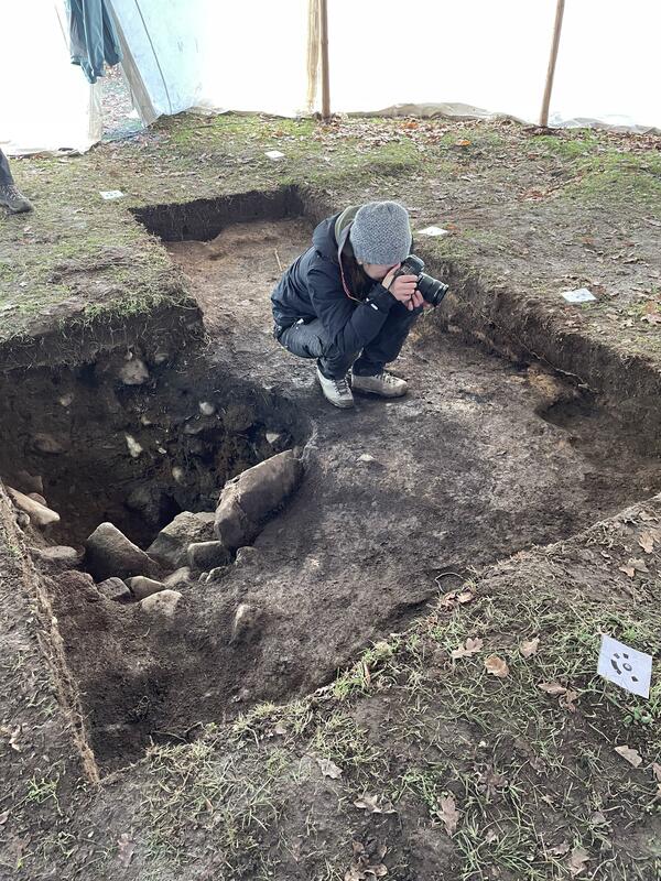
Initially, previously excavated material (mainly backfill from 2017) was removed to expose the latest phase of the investigation. Once reached, the layer was carefully cleaned and then documented with a digital camera.
The technique of using digital photography, combined with accurate digital positioning, is extremely important for research on the hill. This approach makes it possible to create 3D models of the contexts and features recovered during the survey, and provides a clearer description of the complex stratigraphic sequence encountered during the investigation.
Individual strata, burials and finds are described and given different digital identities so that they can be distinguished in databases and used to support archaeological interpretation.
The end result is a coherent digital information chain linked to databases and high-resolution images of trenches, strata and finds. The archaeological evidence is gone forever, but the computer can simulate the progress of the investigation through the various stages. With a consistent working method, it is then possible to piece together puzzles from different seasons of fieldwork, as information and 3D photogrammetry can be merged into a larger whole.
Stones laid in orderly rows or as packed surfaces constitute concrete and highly residual traces on the hill. However, when it comes to interpreting the remains of houses, it is what is not visible or preserved that must be taken into account in the interpretation.
The walls themselves have disappeared but finds of mud bricks at least suggest that there were walls at some point. A roof or other superstructure would have had some kind of support. The outline of a 10x5 meter house has been identified on the 2012 georadar images. These showed concentrations of stone in places within the proposed building.
During the 2021 fieldwork, the ground was excavated immediately adjacent to such a concentration, which eventually turned out to be a up to one meter across. The deep pit was filled with larger stones and gave the impression that it had been moved when necessary during the period of use. Here there was not even the negative impression of a wooden roof-supporting post, but a situation which could still be interpreted as the previous existence of one or more such posts.
Even more abstract traces of what happened on the hill are hidden in the soil layers themselves. Plant parts, pollen, charcoal and soil chemical traces can also contribute to the interpretation of the site's archaeology. Ongoing sampling for future analysis is therefore of great importance to the project, as complex stratigraphic and contextual issues must be weighed against a more or less comprehensible, and to varying degrees fragmentary, find material.
The complexity becomes most apparent when we consider the extensive presence of copper alloys found on the mound. The mask image that emerged in 2004 was followed in 2013 by numerous other finds of the same or similar character. Most of these are thought to be associated with bronze vessels and pots from the Celtic/Roman period up to the 5th-6th century AD. There are fully comprehensible handles and supports, clear belly and mouth fragments, and artistically executed decorative elements. Many of the finds are otherwise badly degraded, irregular, and difficult to interpret. What is certain is that all these fragments represent several different objects that were distributed and deposited at different levels and floor layers within the ritual building on the hill. Several such artefacts were also found during fieldwork in 2021.
One example is a cast holder for the handle or handle of a cauldron. Another is a thin, hammered, and riveted fragment of the rim of a cauldron. The thin bronze shows what appears to be part of the hairstyle of a person or deity.
Further research on the vessels and cauldrons is time-consuming and complicated. As usual, 3D photogrammetry is carried out as part of the field documentation. In the case of finds, this is often supplemented by further digital scans of objects before and after conservation. The high-resolution 3D models are finally available and can be studied individually or together with similar artefacts found in the vicinity of the hill. The puzzle of reconstructing the broken pots and vessels can be solved digitally, but is also anchored in further detailed studies of the actual finds, their alloy content and, not least, how they were destroyed and finally deposited on the site.
We have seen that some artefacts were found in poor condition on the hill, not least because of the fragmented bronzes. However, there are other materials that are problematic in terms of conservation. These should not be ignored just because they are not made of precious metal. One such object appeared in season 2021, a heavily rusted 20 cm long object that was difficult to type in the field , like in the case of find
After conservation, however, it became clear that the object was a Migration Period lance head.
Weapons are not very common in Iron Age settlements. The fact that several arrowheads, lance and spearheads and sword parts have been found at Vång underlines the special status of this particular settlement. In particular, the weapons found on the hill, and especially in the ritual building, must be evaluated in terms of what special function they may have had in such a special environment.
In some situations, finds may be encountered in such a way that they cannot be fully associated with undisturbed strata or sites. However, they can still be linked to an overall picture. The gold foil figures of the hill, known as guldgubbar (click here to see all the guldgubbar from Vång), are examples of such finds.
Some of these have been found quite superficially within the area of the remains. Most are otherwise clearly associated with the silty, deposited soil layers and then at the same level as most of the glass beaker fragments found on the mound. In 2021, a foil figure appeared at the edge, a little lower in the larger posthole. The fact that a fragment of a more recent chalk pipe also appeared at the bottom of the posthole suggests that someone, perhaps in the 17th or 19th century, may have rearranged the stratigraphic sequence. This tendency to rearrange the context could also be observed in the soil layer of the posthole. The lesson is that finds are not necessarily in their original position just because we in modern times consider the remains as a whole to be largely untouched and unaltered.
The overall testimony of the 2021 finds was in line with expectations, both in terms of quantity and degree of preservation. The same was true for the knowledge gained from the documentation and excavation of the layers and structures within the six square metre survey area. Further research into the depths of the remains on the hill will gradually complete the picture.


")
| Plane | Position | Flip |
|
|
||
|
|
||
|
|
| Show planes | Show edges |
0.0
[ 0 , 0 , 0 ]