Dates
Address
Institutions
Blekinge Museum
Responsibles
Nilsson, Björn
Participants
Derudas, Paola
Löfving, Axel
Helgesson, Bertil
- 1. VV2019 Aims, Methods and Implementation
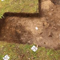
- 2. VV2019 Trench location and extension
- 3. VV2019 Trench A North part; contexts 1016, 1017 and 1021
- 4. VV2019 Trench A North part; context 1020
- 5. VV2019 Trench A North part; contexts 1020 and 1035
- 6. VV2019 Trench A Middle part; contexts 1022 and 1019
- 7. VV2019 Trench A Middle part; context 1013
- 8. VV2019 Trench A Middle part; context 1013 finds
- 9. VV2019 Trench A Middle part; context 1006 (posthole fill 1)
- 10. VV2019 Trench A Middle part; context 1030 (posthole fill 2)
- 11. VV2019 Trench A Middle part; context 1034 (posthole fill 3)
- 12. VV2019 Trench A Southern extension; context 1002
- 13. VV2019 Trench A Southern extension; context 1002 finds
- 14. VV2019 Trench A Southern extension; contexts 1026, 1027 and 1028
- 15. VV2019 Trench A Southern extension; context 1028
- 16. VV2019 Trench A Southern extension; context 1005
- 17. VV2019 Trench A Southern extension; context 1005 - finds distribution and root disturbances
- 18. VV2019 Trench A Southern extension; contexts 1029, 1032 and 1033
- 19. VV2019 Trench A South; contexts 1025, 1013 - end of excavation
- 20. VV2019 Trench A Middle; contexts 1013, 1031 - end of excavation
- 21. VV2019 Trench A North; contexts 1020 and 1035 - end of excavation
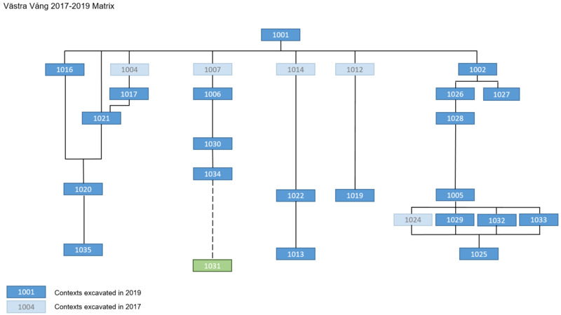
- 22. VV2019 Trench A Stratigraphic summary VV2019
- 23. VV2019 Trench A Stratigraphic summary VV2017-VV2019 combined
- 24. VV2019 Trench A Finds recording and retrieval
- 25. VV2019 Trench A Finds - contextual interpretation
The settlement at Västra Vång is placed in close proximity to the Johannishus ridge. This partly prominent esker constitutes the dominant landscape feature of the region, providing the north-south-running valley with its specific character through a combination of undulating high-points and formerly numerous wet-areas. The higher terrains east and west of the valley consist of woodland, whereas the valley itself is almost exclusively dominated by agrarian land-use. The archaeological landscape is characterized by graves of Bronze- and Iron Age date, placed at high-points in the terrain. The lower agrarian terrain within the valley shows evidence of settlement sites dated from the Neolithic and onwards. Only a few of these are surveyed and recorded. The Medieval village of Vång has not been affected by later agricultural land reform, and was since the 17th century, or possible earlier, divided into two units. One located east of the valley and one west. The village was since the late 17th century incorporated in and under the control of the estate of Johannishus. Evidence of earlier activity within the village have especially been recorded in connection with agricultural land surrounding the minor plateau in the middle of the valley (L1978:8860, RAÄ Hjortsberga 306 and surroundings). The investigation of these activities have produced dates from Pre-Roman Iron Age to late Viking Age.
The aim of the camping of 2019 was to enhance the results of 2017 and 2018, and thereby providing a more complete knowledge base for future large-scale investigations of the site complex. The goal was therefore, in accordance with the investigation plan approved by the County administrative board, to complete the investigation and recording of the trenches and investigation areas previously started on the Vång hill and in the settlement area east Tvingvägen. In addition, metal detection surveys was conducted within several defined investigation areas of the site complex.
The excavation of trenches was placed within the recorded sites L1978:8860, RAÄ Hjortsberga 306, and L1978:4818, RAÄ Hjortsberga 121 respectively. In summary, the 2019 campaign recorded additional contexts and finds within previously partly investigated areas, and added additional spatial information of the site complex as a whole through metal detection surveys.
Method and implementation
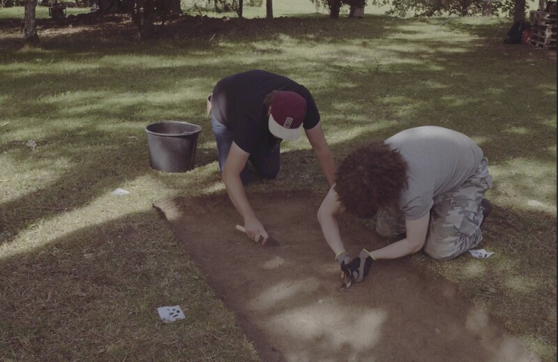
The trench (Trench A) opened within L1978:8860, RAÄ Hjortsberga 306 measured 13 m2. Exposed contexts and finds were recorded in situ with Image-based-modeling. The excavation was then carried out with single-context method. Excavated fills and layers were water-sieved. One larger feature was partly excavated after consultation with the County administrative board. Sampling was made selectively and with the aim of future macro-fossil analysis.
Metal detection was systematically carried out within predefined investigation areas. The retrieved finds were manually recorded using field maps and later digitized post-excavation. No detection points that were ascertained to be related to underlying archaeological contexts were excavated during the campaign.
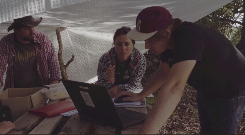
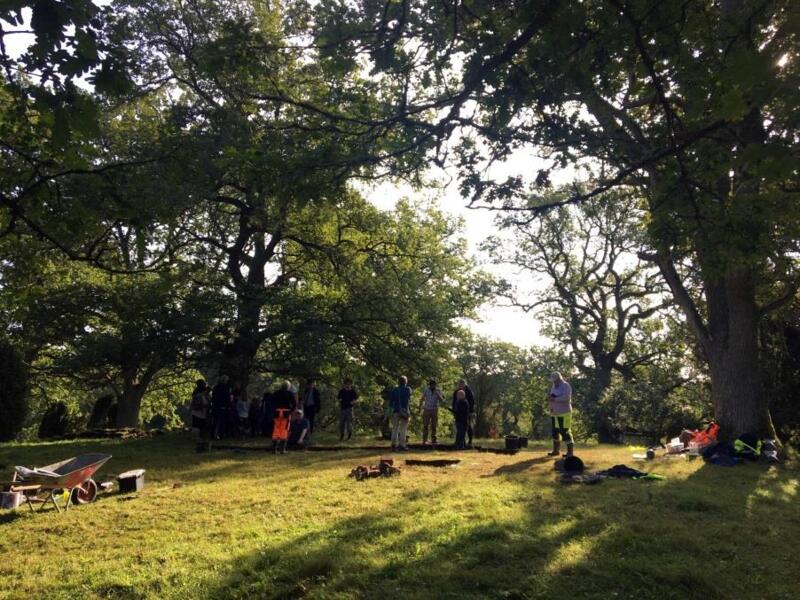
The field- personnel consisted of a team from Blekinge museum, Lund University, The Archaeologists – National Historical Museums and Södertörn University. Jonas Paulsson, Kula AB was responsible for and conducted the metal detection survey. Additional total-station survey was made by Niclas Olsson, Blekinge mätservice and conservation work was conducted by Max Jahrehorn, OxiderAB. The find-list was compiled by Andreas Svensson, Lund University. Visual inspection analysis of ceramics and burnt clay was conducted by Torbjörn Brorsson, Kontoret för Keramiska Studier. Public mediation was focused on a continuous exhibition of artefacts at Kallvattenkuren, Ronneby Brunnspark. Public evening lectures showcasing results from the ongoing excavations were also given in Ronneby. A film consisting of drone footage and interviews with project participants was compiled for Lund University by Lars Persson-Tille, Lars Nilsson and Nicolas Tegsell.
Trench A was placed matching the location of Trench A from the campaign 2017 in its extension as of 26/08/2017 end of excavation. The topsoil was removed until the stratigraphy as of end of excavation 2017 was reached. Depth of topsoil ranging between 0,15m to 0,25m. The exposed surface was manually cleaned and an IBM acquisition was made.
The trench was then extended in the southern part by 3,00 meters in western direction. The topsoil in the extension was removed and the surface manually cleaned, after this another IBM acquisition was made. The full extension of Trench 2019 had an inverted L-shape with a typical breath of 1,00 meter, except for its southern corner where the breath was 2,00 meters.
The contexts 1016 and 1017 were identified in the 2017 campaign and interpreted as part of the stone constructions uncovered in previous excavations (Henriksson 2015).
They were partially excavated in 2017 and fully excavated in 2019. The contexts were very similar in composition and contents (1016; 1017), both consisting of fist-sized stones and without bonding material. Finds of burnt bones and iron fragments were retrieved from the contexts.
Context, consisted of light greyish brown clayey sand, with fatness increasing in its south part(see context 1021). The layer contained small to medium-sized stones. Context 1021 was first sectioned N-S leaving an east-facing section, then fully excavated.
After removal of contexts 1016, 1017 and 1021, context 1020 was exposed covering the entire northern section of Trench A.
Context 1020 was exposed below contexts 1016, 1017, and 1021. Also, context 1004 from the 2017 campaign and located between context 1016 and 1017 was overlaying the layer.
Context 1020 consisted of light brown sandy silt with inclusions of larger stones unevenly spread within the layer. The layer was interpreted as following the entire trench extent and continuing beneath contexts not yet excavated in the middle part of the trench (see paragraph6). For this reason, only a small portion of the context was excavated (see paragraph 5) at the end of the campaign in order to gauge its depth and secure an environmental sample (Sample 15).
One square meter of context 1020 was excavated two meters south of the north trench edge. Below 1020, context 1035 was identified. Context 1035 consisted of red brown gravely sand with inclusions of unevenly spread larger stones. The transition between contexts 1020 and 1035 was very gradual. Context 1035 was interpreted as a possible lower foundation for overlying contexts 1016, 1017, and 1021. Alternatively, culturally affected natural subsoil.
Context 1035 was only exposed in an area of one square meter.
Context 1022 was partially excavated during the campaign of 2017. The context consisted of very compact yellowish-grey silt. The context was interpreted as a possible floor layer.
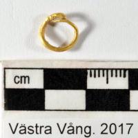
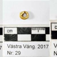
In the interface between context 1022 and underlying context 1013, a bronze ring in poor condition was recorded and retrieved as a block, see paragraph 8.
South of the posthole (1031) an irregular layer similar in composition and compaction to 1022 was excavated. This context was identified and partially excavated during the campaign of 2017 and recorded as context 1019. In 2017 the layer was interpreted as a small leveling layer. The excavation of 2019 could revise this interpretation of the context as a patchy remain of a floor surface and a similarity between contexts 1022 and 1019 was established. After full excavation of context 1019, context 1013 was identified as covering all the area surrounding the posthole (1031), see next paragraph.

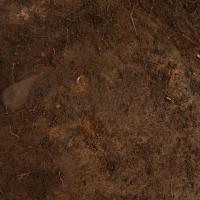
Context 1013 was exposed below the floor layer 1022. It consisted of greyish-black sandy silt. Soot was abundant within the layer, and it was interpreted as a possible lower floor surface. Context 1013 was cut by posthole 1031, but the relationship between posthole 1031 and the floor surfaces 1022 and 1013 need to be further established in future campaigns. In the exposed upper part of the context 1013, finds A97, A98, and A99 were recorded and retrieved (next paragraph).
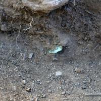
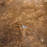
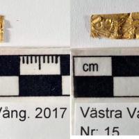
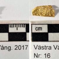
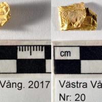
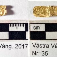
During the 2017 campaign, a subcircular feature (1006) was identified in the middle part of Trench A. After full excavation in the 2019 campaign it was determined that the feature was a larger posthole and context was its uppermost fill. Among the finds retrieved from context 1006 in 2019 were two gold foil figures A58 and A64.
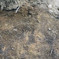
Context 1030 was identified below context 1006. The context was interpreted as a loose backfill of the posthole (context 1031). The fill consisted of dark yellowish-brown sand with inclusions of clay, charcoal, and pebbles.
Below context 1030, a lower fill of the posthole (context 1031 documented in 2021) was exposed, context 1034. The fill consisted of light brownish-yellow silt. The context was not excavated during the 2019 campaign.
After topsoil removal and cleanup of the southern extension of trench A, context 1002 was exposed. This context was interpreted as corresponding to context 1002 identified and excavated during the 2017 campaign in Trench B. The context is a thin gravely layer below the topsoil with a depth of 8 centimeters.
Finds A61, A62 and A63 were recorded in situ at the interface with the underlying context 1005 (see next paragraph).
After excavating context 1002 two subcircular possible features were identified and recorded as context 1026 (fill), 1028 (cut), 1027 (possible feature).
Feature 1028 was located west of 1027 in the middle of the extension and it was an irregular oval pit with one recorded fill (1026).
The possible feature 1027 during later excavation was interpreted as a root disturbance.
After full excavation of features 1028 and 1027, it was possible to interpret 1028 as a pit with one fill (1026), but 1027 is most likely to be interpreted as a root disturbance (see paragraph 18).
After the removal of context 1002 and the excavation of 1028, context 1005 was identified.
The context was interpreted as a floor surface or a leveling surface for a planked area. The context consisted of silty sand and corresponded to context 1005 recorded in the 2017 campaign, east of the southern extension of trench A in the campaign of 2019.
Substantiating the interpretation of context 1005 as a floor layer, several of gold, glass, Cu-alloy, and daub were recorded in situ within the context ( See next paragraph).
From the distribution of finds recorded in situ within context 1005 it could be determined that most of the finds of glass, gold and Cu-alloy were identified in connectionto the root disturbance area (contexts 1027, 1029, 1032, 1033) centrally located in the trench extension. This could support an interpretation that this area represents a feature, possibly a pit, truncated by root activity. Since no clear cuts could be recorded for such a presumed feature , the interpretation remains tentative.
A singular gold foil figurine (A71) was recorded in situ at the western edge of the trench extension. The precense of a group of larger stones in proximity to this find could indicate that another possible feature is present close to the western trench wall of the trench extension. No clear cut could however be observed for such a presumed feature when studying the east-facing section of the trench extension, and hence the indication is uncertain.
After excavation of context 1005 and the area of root disturbance (contexts 1027, 1029, 1032, 1033) the entire south extension was interpreted as containing one continuous layer, context 1025. This layer was interpreted as a lower support layer/leveling layer for context 1005 above. Alternatively, context 1025 could represent an earlier floor surface, due to its similar characteristics to context 1005.
Context 1025 was not excavated during the 2019 campaign. From surface inspection, it could be determined that the layer was heavily truncated by root disturbance, with larger stones more present in comparison to overlying layer 1005. This seems to support an interpretation as a support layer/leveling layer, but this hypothesis needs to be determined by future excavation.
In the southwest corner of Trench A, the stratigraphical relationship between contexts 1013 and 1025 still remains unclear as of end of excavation 2019. It may very well be that context 1013 gradually ends approximately half a meter from the edge of posthole 1031 and that no clear stratigraphic relationship between 1013 and 1025 can be established, i.e. contexts 1013 and 1025 are on the same stratigraphic level. However, this has to be established by future excavation.
As of the end of excavation 2019, in the middle part of Trench A, the third fill of posthole 1031 (context 1034)was exposed but not excavated. The 2019 campaign could establish that posthole 1031 had a minimum breath of 1,30 metres and that the sides of the cut were lined with larger stones. Several of these stones were interpretated as support stones recorded in situ or at least minimally disturbed. The depth of the posthole could not be established, but it's strongly suggested that the posthole was backfilled by at least three fills. The upper fills (1006 and 1030) differed considerably in character, whilst the third fill (1034) appeared to be more similar in terms of composition to the second fill (1030). The stratigraphic position of posthole 1031 could not be fully established during the 2019 campaign. The starting hypothesis that the posthole was contemporary to the floor surfaces 1005, 1019, and 1022 but cut into underlying layer 1013 could not fully be proven or disproven since the full cut of the posthole was not excavated. It is, however, likely that the original post was contemporary to the floor surfaces. These surfaces could be recorded as abuttning the second backfill (1030) rather than being sharply truncated by the same. The upper backfill (1006) could very well have been a later addition to the postholes backfill, added after the lower backfills had been compacted, leaving a sunken depression at the top. The stratigraphic relationship between the posthole cut (1031) and layer 1013 remains to be established in future excavation.
Layer 1013 was, as of the end of excavation 2019, interpreted as covering the entire middle section of Trench A surrounding the posthole. The depth of the layer was not established. Several aspects and hypotheses needs to be taken into account for future excavation of the layer. Firstly, the stratigraphic relationship to the posthole needs to be clarified. Secondly, the function, formation process and depth of the context needs to be established. In this regard, several hypotheses can be forwarded. The layer can represent a burning event before the floor surfaces were constructed. Context 1013 can also represent burning and/or debris events inbetween floor sequences. From the excavations of 2019 it is clear that context 1013 contains a large part of the find material consisting of fragmented bronze cauldrons and additional materials in Cu-alloy. It is not unlikely that many of the Cu-alloy objects retrieved in earlier campaigns on the Vång hill (bronze masks, cauldron rings and loop holders, etc.) have their stratigraphic origins in context 1013. This provides excellent oppurtunity in future excavation for interpretations as to the type of activity represented by the context, but it also present considerable challanges in terms of excavation pace and conservation cost.
As of end of excavation 2019, context 1020 was recorded as covering the entire northern part of Trench A (see paragraph 5 for a more thorough description). Context 1020 was interpretated as a subsurface or an older ground horizon, possibly humanly altered in connection with the construction of stone constructions in the area. It is hypothesized that 1020 continues southwards in the middle part of the trench and hence is covered by stratigraphy not yet excavated in that area.
One square meter of 1020 was excavated in the northern part of the trench in order to gauge its depth and possible function. At a depth of 0,20 to 0,25 m context 1020 gradually transitioned into a lower context (1035). This context was interpreted as a lower leveling layer or natural subsurface with infiltration.
Northern part (left side in the matrix): interpreted as part of the outdoor stone structures that were identified in 2012-2013. During the campaign of 2019, the following contexts within this complex were fully excavated: 1016, 1017, and 1021 [see paragraph 3]. Below contexts 1016, 1017, and 1021 a larger context was identified,1020. One squared meter of this context was excavated and context 1035 was identified below [see paragraph 5].
Middle part (central part in the matrix): interpreted as one larger backfill posthole and surrounding floor and activity layers. Two fills of the posthole (1006 and 1030) were excavated in 2019, and a third fill was identified but left unexcavated (1034). Although not fully exposed, the cut of the posthole was given a context number 1031 (see paragraphs 9, 10, and 11).
Floor layer 1022 surrounding the posthole on its northern side was also excavated, exposing the context 1013 burning activity layer completely throughout the middle part of Trench A (see paragraph 6, 7, and 20).
Southern part (right side in the matrix): interpreted as floor surfaces (1019, 1005, 1025)(see paragraphs 16, 17, 19) truncated by several root disturbances (1026, 1027, 1029, 1032, 1033) (see paragraphs 14, 15, 18). Between the topsoil and the floor surfaces, 1005 and 1019, context 1002 was identified. 1002 was interpreted as an interface between topsoil and underlying floor surfaces and was first identified in Trench B during the excavation campaign 2017 (see paragraphs 12 and 13).
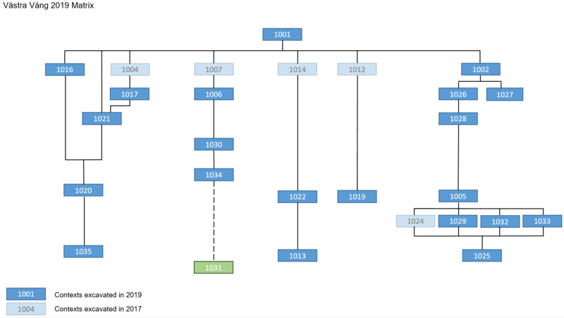
Northern part (left side in the matrix): interpreted as part of the outdoor stone structures that were identified in 2012-2013. During the campaigns of 2017 and 2019, the following contexts within this complex were fully excavated: 1004, 1016, 1017, and 1021 (see paragraph 3, and Report 1 2017). Below contexts 1004, 1016, 1017, and 1021 a larger context was identified,1020. One squared meter of this context was excavated, and context 1035 was identified below (see paragraph 5).
Middle part (central part in the matrix): interpreted as one larger backfill posthole and surrounding floor and activity layers. Obstructing the top fill of the posthole was a root disturbance (context 1007) that was excavated in 2017 (see Report 1 2017). Two fills of the posthole (1006 and 1030) were excavated in 2019, and a third fill was identified but left unexcavated (1034). Although not fully exposed, the cut of the posthole was given a context number (1031) (see paragraphs 9, 10, and 11).
Root disturbance 1014 was excavated in 2017, exposing floor layer 1022 surrounding the posthole on its northern side. This context was excavated in 2019, exposing context 1013 burning activity layer completely throughout the middle part of Trench A (see paragraphs 6, 7, and 20).
Southern part (right side in the matrix): interpreted as floor surfaces (1019, 1005, 1025) (see paragraphs 16, 17, 19) truncated by several root disturbances (1026, 1027, 1029, 1032, 1033) (see paragraphs 14, 15, 18). Between the topsoil and the floor surfaces, 1005 and 1019 context 1002 was identified. 1002 was interpreted as an interface between topsoil and underlying floor surfaces and was first identified in Trench B during the excavation campaign 2017 (see paragraphs 12 and 13).

A total of 145 finds were retrieved from the excavation of Trench A during the campaign of 2019. Of these, 63 finds (43%) were metal detection finds retrieved in a survey area surrounding Trench A (can we visualize this area and the finds?). Metal detection was conducted by Jonas Paulsson (Kula AB) using a high-frequency detection head (HF-coil). The position of the metal detection finds was recorded by total station survey.
Of the 82 (57%) finds retrieved by excavation within the contexts of Trench A, almost half (34 finds) were recorded in situ by IBM. The position of these finds was calculated from the 3D models produced. 45 finds were collected by handpicking during excavation of contexts and only 3 finds were retrieved by sieving.
The metal detection finds consisted mostly of Cu-alloy (51 finds), followed by precious metals (11) and a single recorded find of slag (VV2019_H3 Link).
The finds retrieved from the excavation of contexts within Trench A consisted of Cu-alloy fragments and objects (20 finds), daub fragments (15 finds), burnt bone (13 finds), glass shards (10 finds), ceramic sherd (5 finds), iron fragments (4 finds), burnt flint (3 finds) and resin fragments (2 finds). In addition, 1 piece of worked quartz was also retrieved.
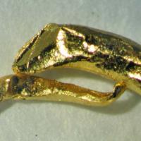
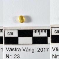
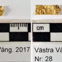
6 gold foil figures and 1 gold ring were recorded in situ. 7 gold foil figures and 1 gold ring were retrieved by metal detection. In addition, 1 gold foil figure and 1 gold ring were retrieved from sieving.
The find material consisting of ceramics from the campaign of 2019 was very limited, only comprising 5 finds. All of these were handpicked from the excavation of context 1001 (topsoil), context 1005 (floor surface), context 1013 (burning event), context 1020 (subsurface), and context 1033 (root disturbance).
To occurrence of only one or two ceramic sherds within each of these contexts supports an interpretation that ceramic vessels were not frequently occurring within the activities undertaken within Trench A on the Vång hill. The contexts excavated do not represent debris layers from ordinary settlement activity as has been recorded for certain subareas of the excavation area east of the Tving road (RAÄ Hjortsberga 121).
This contextual interpretation as well as the morphological characteristics of the sherds retrieved matches observations during earlier excavation campaigns within the Vång site complex (Henriksson 2021 appendix 4).
In comparison to ceramics, daub was more frequently retrieved from the contexts excavated in 2019. 19 fragments (Find A 63, Find A100, Find A101 ) were retrieved from the topsoil and the interface layer context 1002. 10 fragments (Find A 78, Find A 85, Find 112 ) were retrieved from the floor surface context 1005 and 7 fragments from one of the major root disturbances context 1033. Daub fragments were also retrieved from the posthole (1031), with 14 fragments attributed to the upper fill (1006) and 22 fragments attributed to the second fill (1030). One singular daub fragment (Find A 120) was also retrieved from burning event context 1013.
Despite making up a large portion of the total finds material retrieved, the daub fragments are interpreted as scattered material and not as representing deliberate or accidental destruction of constructional features or debris layers from such activity. This interpretation is substantiated by the daub fragments recorded in situ (Finds A63, A66, A67, A68, A69, A70, A78, A85). From this documentation, it can be deduced that the daub fragments don't form concentrated clusters but rather appear as scattered material present within the fill material.
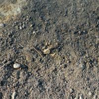
A few fragmented finds of iron were retrieved from contexts in Trench A. These comprise flatrods (Find A90, Find A119, Find A131) and iron fragments (Find BLM29459 121 not in the database). 3 of the 4 flatrods retrieved were connected to the floor surface context 1005 and underlying layer context 1025, and 1 flatrod was attributed to burning event context 1013. The iron fragments (Find BLM29459_121 not in database) were attributed to small leveling layer context 1012.
The iron flatrods and fragments should most likely be given an interpretation as broken and discarded objects.
Burnt bone was relatively frequently retrieved from the contexts in Trench A. 12 fragments were attributed to interface layer context 1002 (Find A105). 13 fragments were retrieved from the stone packings in the north part of the trench, with 4 fragments attributed to the upper context 1016 (Find A124) and 9 fragments attributed to the lower subsurface context 1020 (Find A127). 23 fragments were retrieved from floor surfaces context 1005 and context 1022 (Find A92, Find A107, Find A129). 22 fragments were retrieved from the posthole context 1031, with 2 fragments attributed to the upper fill context 1006 (Find A117 ) and 20 fragments attributed to the second fill context 1030 (Find A133). 8 fragments were retrieved from the root disturbances contexts 1027, 1029, 1033 (Find A130, Find A132, Find A141).
Pending osteological analysis, the interpretation of the burnt bone material remains uncertain. A few suggestions can, however, be made on the grounds of contextual interpretation. The previously suggested interpretation of the stone structures investigated in the north part of the trench as grave structures could be neither proven nor disproven in light of the burnt bone material retrieved. This material, whether animal or human in origin, could very well represent scattered debris from bone deposits or ritual activities in connection with the stone structures. The small frequency of fragments does, however, make such an interpretation merely tentative. More fragments were retrieved from the underlying subsurface layer (context 1020) than from the stone packings (context 1016), which also makes the previous interpretations uncertain. The burnt bone material retrieved from the floor surfaces (contexts 1005, 1022) and the posthole backfills (contexts 1006, 1030) most likely represent scattered debris material. The frequency of fragments does not appear to be clustered within any specific context or part of the context. Instead, the fragment frequency of retrieved burnt bone material seems relative to the amount of excavated soil from the investigated contexts. This would imply that the scattering of bone debris within the contexts of Trench A was relatively even.
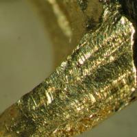
The find material in Cu-alloy retrieved from contexts within Trench A was relatively numerous, consisting of sparse metalworking debris in copper-alloy from contexts 1013 (Find A99), 1019 (Find A60), 1025 (Find A59)
Metalworking debris from metaldetection of the topsoil include Finds H1, H4, H5, H6, H7, H8, H9, H11, H12, H13, H14, H15, H17, H18, H20, H21, H22, H23, H24, H27, H28, H29, H30, H31, H34, H35, H36, H37, H38, H39, H40, H41, H42, H43, H45, H47, H48, H50, H52, H53, H54, H57, H81 ).


")
| Plane | Position | Flip |
|
|
||
|
|
||
|
|
| Show planes | Show edges |
0.0
[ 0 , 0 , 0 ]