Identifier

GH2019_T_1_L3

Title

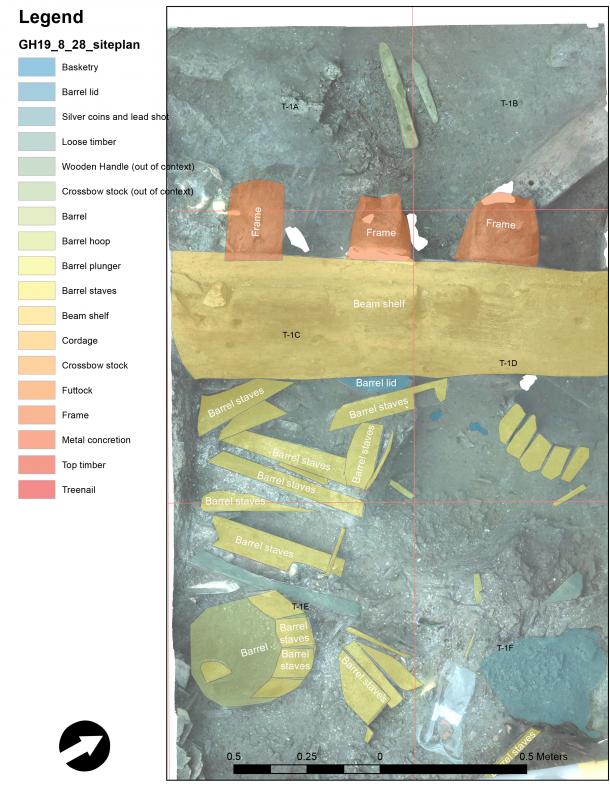
GH2019 trench 1 layer 3

Description

The third layer of the rectangular 6 x 2-meter large trench excavated on the starboard side amidships with NW-SE orientation. 

Record creator

P. Derudas

Investigation site

Gribshunden

Investigation dates

August 29, 2019

Investigation technique

en

Model measure unit

en meter

Longitude shift

513000

Latitude shift

6222000

Spatial reference system (EPSG)

EPSG:3006

Date Created

May 11, 2021

Rights Holder

LU

License

en CC-BY 4.0


Linked resources

Items with "Investigation area: GH2019 trench 1 layer 3"
GH2019 find A56
GH2019 find A57
GH2019 find A58
GH2019 find A59
GH2019 find A60
GH2019 find A63
GH2019 find A8
GH2019 find A9
Items with "Trench(es) described: GH2019 trench 1 layer 3"
GH2019 Report 1


PlanePositionFlip


Show planes Show edges
Measured length
0.0
Coordinates (EPSG:3006)
[ 0 , 0 , 0 ]
Layers:
Check All
Models
GH20190829_1
Contexts
GH20190829_L3_Futtock1
GH20190829_L3_Futtock2
GH20190829_L3_Futtock3
GH20190829_L3_Futtock4
GH20190829_1
GH20190829_barrel1
GH20190829_barrel2
GH20190829_barrel3
GH20190829_1
GH20190829_L3_barrelstave1
GH20190829_L3_barrelstave2
GH20190829_L3_barrelstave3
GH20190829_L3_barrelstave5
GH20190829_L3_barrelstave6
GH20190829_L3_barrelstave7
GH20190829_L3_barrelstave8
GH20190829_L3_barrelstave9
GH20190829_L3_barrelstave10
GH20190829_L3_barrelstave11
GH20190829_L3_barrelstave12
GH20190829_L3_barrelstave13
GH20190829_L3_barrelstave14
GH20190829_L3_barrelstave15
GH20190829_L3_barrelstave16
GH20190829_L3_barrelstave17
GH20190829_1
GH20190829_frame1
GH20190829_frame2
GH20190829_frame3
GH20190829_frame4
GH20190829_1
GH20190829_crossbow stock
GH20190829_1
GH20190829_metal concretion
GH20190829_1
Units
1 / 1
GH20190829 siteplan