Identifier
Title
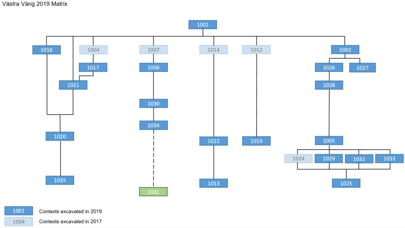
Description
Northern part (left side in the matrix): interpreted as part of the outdoor stone structures that were identified in 2012-2013. During the campaign of 2019, the following contexts within this complex were fully excavated: 1016, 1017, and 1021 [see paragraph 3]. Below contexts 1016, 1017, and 1021 a larger context was identified,1020. One squared meter of this context was excavated and context 1035 was identified below [see paragraph 5].
Middle part (central part in the matrix): interpreted as one larger backfill posthole and surrounding floor and activity layers. Two fills of the posthole (1006 and 1030) were excavated in 2019, and a third fill was identified but left unexcavated (1034). Although not fully exposed, the cut of the posthole was given a context number 1031 (see paragraphs 9, 10, and 11).
Floor layer 1022 surrounding the posthole on its northern side was also excavated, exposing the context 1013 burning activity layer completely throughout the middle part of Trench A (see paragraph 6, 7, and 20).
Southern part (right side in the matrix): interpreted as floor surfaces (1019, 1005, 1025)(see paragraphs 16, 17, 19) truncated by several root disturbances (1026, 1027, 1029, 1032, 1033) (see paragraphs 14, 15, 18). Between the topsoil and the floor surfaces, 1005 and 1019, context 1002 was identified. 1002 was interpreted as an interface between topsoil and underlying floor surfaces and was first identified in Trench B during the excavation campaign 2017 (see paragraphs 12 and 13).

Record creator
Date Created
Rights Holder
License
Linked resources
| VV2019 report 3 Trench A |


")