Identifier
en
TARP2023_SU_10012
Title
en
TARP2023 Stratigraphic Unit 10012
Phase type
en
Fill
Description
en
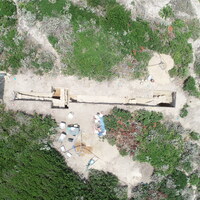
SU 10012 represents an equivalent layer to that of SU 10011 to the east of the basalt outcrop. SU 10012 turned out to be a very deep fill layer that was also quite waterlogged after the rain, perhaps because the presence of the bedrock didn’t allow the water to soak away. SU 10012 was a very loose soil, with many pieces of broken ceramics, as well as pockets of bone and shell. In the course of excavating SU 10012, several large stones came to light as a part of the rubble we had identified against the basalt outcrop. At first we thought it was just a mass of rubble piled against the basalt, but after enough stones were uncovered it became clear that there was the face of some sort of monumental wall or terrace, built against the bedrock. The fill continued down quite deep, with the eastern face of the basalt curving under itself before we found it again lower down. The wall also did not continue down all the way, and seems to have been built at this lower layer of basalt, though there wasn’t an accompanying soil change.
Record creator
Investigation site
Date Created
May 30, 2024
Rights Holder
en
University of Cincinnati (US)
License
en
CC-BY 4.0
has type
en
Accumulation (abandonment)
O17i_was_generated_by
en
Abandonment/Collapse
AP16i_was_attributed_by
en
R10.6
AP5_removed_part_or_all_of
Linked resources
| TARP2023 Phase R10.6 |
| TARP2023 Trench 10000 |


