The campaign of 2019 left several questions unanswered, specifically concerning the lower stratigraphy of the hill site. For this reason, a smaller excavation campaign, pinpointed at elucidating the thickness of the sooty organic layer and the depth, characteristics and stratigraphic position of the posthole, was executed in 2021.
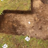
The investigation area was delimited to the posthole and an area around the same covering 6 m2. This trench overlapped with previous excavations, but also include 1 m2 of as yet unexcavated area south of the posthole.
Methods
The trench (Trench A) opened within L1978:8860, RAÄ Hjortsberga 306 measured 6m2. Exposed contexts and finds were recorded in situ with Image-based-modeling. The excavation was then carried out with single-context method. Excavated fills and layers were dry-sieved. Sampling was made selectively and with the aim of future macro-fossil analysis.
Metal detection was systematically carried out within the predifined investigation area (L1978:8860). The retrieved finds were manually recorded using field maps and later digitized post-excavation. No detection points that were ascertained to be related to underlying archaeological contexts were excavated during the campaign.
The field- personnel consisted of a team from Blekinge museum and Lund University. Jonas Paulsson, Kula AB was responsible for and conducted the metal detection survey. Additional total-station survey was made by Niclas Olsson, Blekinge mätservice and conservation work was conducted by Max Jahrehorn, OxiderAB. The find-list was compiled by Andreas Svensson, Lund University. Visual inspection analysis of ceramics and burnt clay was conducted by Torbjörn Brorsson, Kontoret för Keramiska Studier. Public mediation was focused on a continuous exhibition of artefacts at Kallvattenkuren, Ronneby Brunnspark.
Action camera recording was carried out throughout the excavation within the DIAD project (Digital Integration Across Disciplines). The action cameras recorded audio and video of the archaeologists excavating the site.
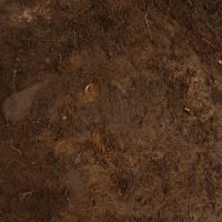
As of the end of excavation 2019, in the middle part of Trench A, the third fill of posthole 1031 (context 1034)was exposed but not excavated. The 2019 campaign could establish that posthole 1031 had a minimum breath of 1,30 metres and that the sides of the cut were lined with larger stones. Several of these stones were interpretated as support stones recorded in situ or at least minimally disturbed. The depth of the posthole could not be established, but it's strongly suggested that the posthole was backfilled by at least three fills. The upper fills (1006 and 1030) differed considerably in character, whilst the third fill (1034) appeared to be more similar in terms of composition to the second fill (1030). The stratigraphic position of posthole 1031 could not be fully established during the 2019 campaign. The starting hypothesis that the posthole was contemporary to the floor surfaces 1005, 1019, and 1022 but cut into underlying layer 1013 could not fully be proven or disproven since the full cut of the posthole was not excavated. It is, however, likely that the original post was contemporary to the floor surfaces. These surfaces could be recorded as abuttning the second backfill (1030) rather than being sharply truncated by the same. The upper backfill (1006) could very well have been a later addition to the postholes backfill, added after the lower backfills had been compacted, leaving a sunken depression at the top. The stratigraphic relationship between the posthole cut (1031) and layer 1013 remains to be established in future excavation.
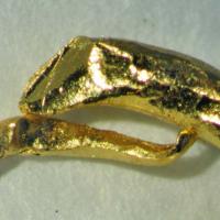
Layer 1013 was, as of the end of excavation 2019, interpreted as covering the entire middle section of Trench A surrounding the posthole. The depth of the layer was not established. Several aspects and hypotheses needs to be taken into account for future excavation of the layer. Firstly, the stratigraphic relationship to the posthole needs to be clarified. Secondly, the function, formation process and depth of the context needs to be established. In this regard, several hypotheses can be forwarded. The layer can represent a burning event before the floor surfaces were constructed. Context 1013 can also represent burning and/or debris events inbetween floor sequences. From the excavations of 2019 it is clear that context 1013 contains a large part of the find material consisting of fragmented bronze cauldrons and additional materials in Cu-alloy. It is not unlikely that many of the Cu-alloy objects retrieved in earlier campaigns on the Vång hill (bronze masks, cauldron rings and loop holders, etc.) have their stratigraphic origins in context 1013. This provides excellent oppurtunity in future excavation for interpretations as to the type of activity represented by the context, but it also present considerable challanges in terms of excavation pace and conservation cost.

After the removal of context 1002 and the excavation of 1028, context 1005 was identified.
The context was interpreted as a floor surface or a leveling surface for a planked area. The context consisted of silty sand and corresponded to context 1005 recorded in the 2017 campaign, east of the southern extension of trench A in the campaign of 2019.
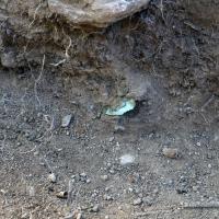
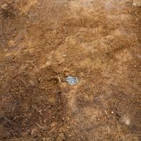
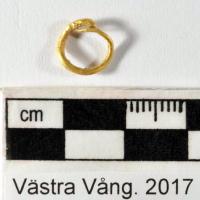
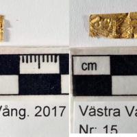
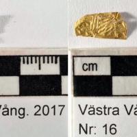
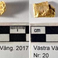
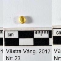
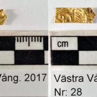
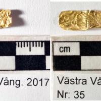
Substantiating the interpretation of context 1005 as a floor layer, several of gold, glass, Cu-alloy, and daub were recorded in situ within the context ( See next paragraph).